DOMINION BOULEVARD CORRIDOR STUDY | Chesapeake, Virginia
42 | Existing Conditions
Existing Conditions | 43
Existing Streets
Airport Features
Existing Streets and Major
Intersections
There are several major roads that provide
access to the Study Area as well as a few
interchanges on Dominion Boulevard. These
existing roads and interchanges form the
starting point for providing a new roadway
network that connects the region together.
Dominion Boulevard is a 4 lane divided
highway. It has limited access points at
Cedar Road, Grassfield Parkway, Scenic
Boulevard, and George Washington
Highway. Dominion Boulevard, the primary
driver of this Study is currently being looked
at as being converted to an Interstate
Highway that will connect Chesapeake
to Raleigh North Carolina. It is a major
component of Chesapeake’s roadway
infrastructure focus and includes an
expansion of a bridge over the Elizabeth
River.
Shillelagh Road and West Road are 2
lane north south connecting roads that
connect rural and suburban development
to Dominion Boulevard. Scenic Parkway,
Grassfield Parkway and Calhoon Parkway
are 4 lane divided roads that access new
development in the northern portion of the
site. Cedar Road and George Washington
Highway provide additional linkages to
Moses Grandy Trail and beyond.
Capitalizing on and leveraging recent
investments in roadway infrastructure is
key. Using existing roadways and locating
new development along existing routes is
also very important from a phasing and cost
standpoint.
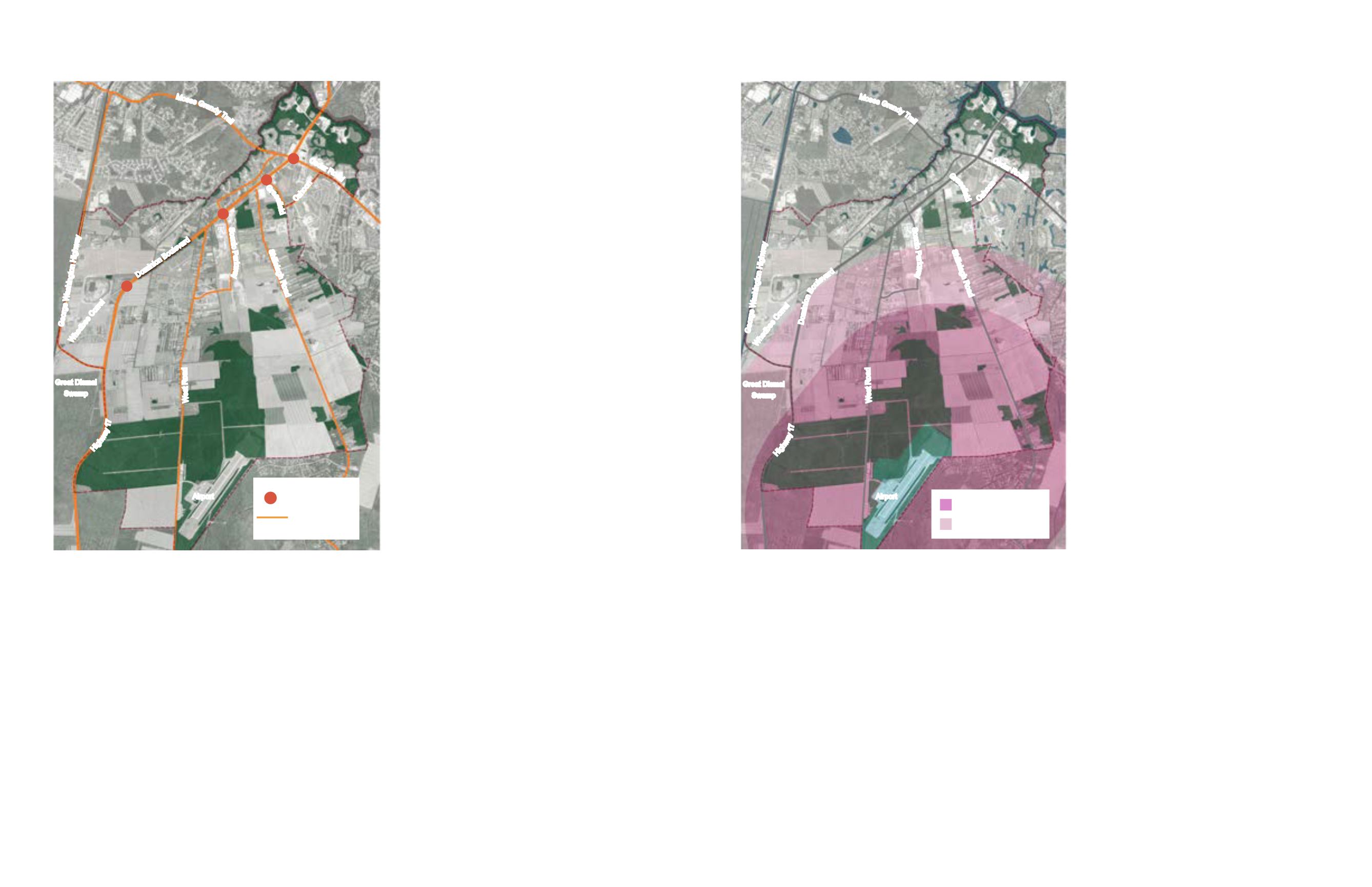
Regional Airport
The Chesapeake Regional Airport is located
in the southernmost part of the Study Area
and provides an important opportunity
to provide synergistic jobs related uses
that can take advantage of regional air
transportation.
The airport currently serves light freight and
private aircraft on its 5,500 foot runway.
Although not currently sized for it, upgrades
to runway lengths to 6,000 feet would enable
it to serve heavier freight oriented aircraft
than in can now, which would magnify its
economic potential.
Although an economic asset, the airport
also creates impacts for new development
due to flight paths for landing and take off as
well as noise. The surface height restriction
is most stringent closest to the airport at
169 feet. This covers a large part of the
agricultural land in the south.
Figure 25: Airport impact areas restrict the height of new buildings
Figure 24: Existing streets and intersections in the study area
Moses
G
r
a
n
d
y
T
r
a
i
l
Ceda
r Ro
a
d
Domi
n
i
o
n
B
o
u
l
e
v
a
r
d
G
r
a
s
s
i
e
l
d
Shillelagh Roa
d
George Washington Highwa
y
Hig
h
w
a
y
1
7
W
e
s
t
R
o
a
d
Scenic Pa
r
k
w
a
y
C
a
h
o
o
n
Whedbee
C
o
r
r
e
l
Airport
Great Dismal
Swamp
Moses
G
r
a
n
d
y
T
r
a
i
l
Ceda
r Ro
a
d
G
r
a
s
s
i
e
l
d
Shillelagh Roa
d
George Washington Highwa
y
Hig
h
w
a
y
1
7
W
e
s
t
R
o
a
d
Scenic Pa
r
k
w
a
y
C
a
h
o
o
n
Whedbee
C
o
r
r
e
l
Airport
Great Dismal
Swamp
D
o
m
i
n
i
o
n
B
o
u
l
e
v
a
r
d
Existing Major Road
Network
Existing Intersection
Horizontal Surface
Restriction (Elevation 369 ft)
Conical Surface Restriction
(Elevation 169 ft)


