 
          DOMINION BOULEVARD CORRIDOR STUDY  |  Chesapeake, Virginia
        
        
          56  |  Planning Frameworks
        
        
          Planning Frameworks  |  57
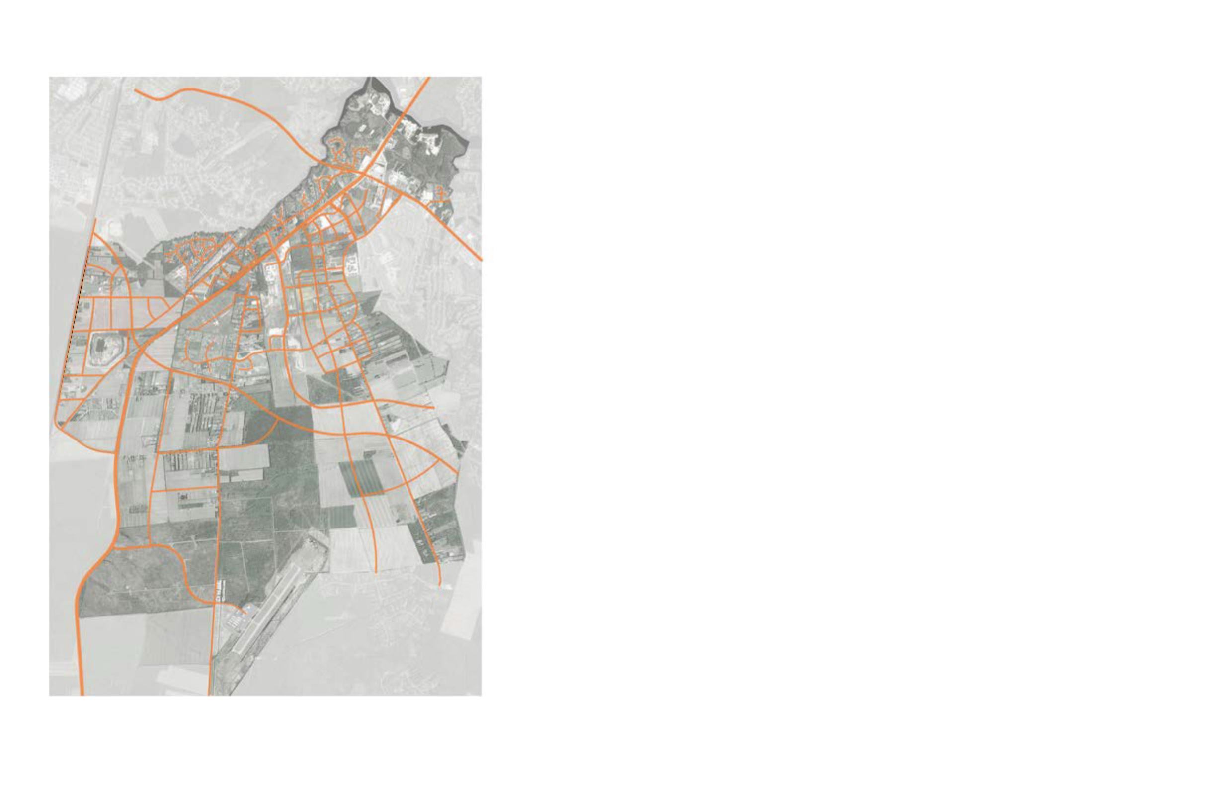
        
        
          Proposed Streets
        
        
          All the streets within the Dominion Boulevard Study
        
        
          Area, in addition to complying with all existing codes,
        
        
          ordinances and design standards, should be designed
        
        
          as “Complete Streets”, which are defined by the
        
        
          National Complete Streets Coalition as streets that
        
        
          “are designed and operated to enable safe access for
        
        
          all users. Pedestrians, bicyclists, motorists and transit
        
        
          riders of all ages and abilities must be able to safely
        
        
          move along and across a complete street.”
        
        
          Conversely, incomplete streets are designed primarily
        
        
          for the car, which limit transportation choices, and do
        
        
          not have the necessary infrastructure to comfortably
        
        
          and conveniently accommodate pedestrians, bicyclists
        
        
          and transit riders in a safe and context sensitive way.
        
        
          Combined with an interconnected street grid, greenway
        
        
          network and transit service, Complete Streets reduce
        
        
          the demand for automobile travel for routine trips and
        
        
          contribute to a healthy community.
        
        
          By providing a variety of street types (Highway 17,
        
        
          parkways, neighborhoods) there is an opportunity to
        
        
          provide equitable, multi-modal transportation networks
        
        
          and connectivity through the neighborhoods, the focus
        
        
          areas, the City and regionally. Street design focused
        
        
          on the implementation of complete streets principles
        
        
          along with designing streets for the appropriate speeds
        
        
          promotes walkability and bikeabilty (multi-modal
        
        
          transportation).


            Implementation Recommendation:


          The Master Plan provides recommended street
        
        
          cross sections that integrate Complete Street design
        
        
          elements. These sections should be used to guide the
        
        
          design of future streets within the Dominion Boulevard
        
        
          Master Plan. In general, the design and engineering of
        
        
          the major streets should:
        
        
          • Acknowledge that, as habits change, transit rider-
        
        
          ship of all types might increase in the future and
        
        
          that accommodations need to be made for that
        
        
          eventuality.
        
        
          • Provide efficient lanes of travel and Level of Ser-
        
        
          vice (LOS) for automobiles (C or D) with the mini-
        
        
          mal amount of lanes needed to create an accept-
        
        
          able LOS with lane widths of between 10 and 11
        
        
          feet.
        
        
          • Utilize design speeds (35 mph or under ideally) that
        
        
          promote safety and a pedestrian friendly experi-
        
        
          ence.
        
        
          • Locate intersections at walkable intervals that are
        
        
          scaled to match the design speed of the street. Ide-
        
        
          ally, most of the major roads within the Study Area
        
        
          will have intersections that don’t exceed 450 - 600
        
        
          feet.
        
        
          • Integrate accommodations for bicycle lanes (6 feet
        
        
          minimum) or cycle tracks into their design.
        
        
          • Provide adequate sidewalk space (6 feet minimum)
        
        
          located behind vegetated buffers (8 feet minimum)
        
        
          planted with continuous and regularly spaced (40
        
        
          feet on center average) street trees.
        
        
          • Promote the place-making context that they are
        
        
          located in (Urban, Suburban, and Rural).
        
        
          • Utilize crosswalks and countdown signals at inter-
        
        
          sections.
        
        
          • Utilize street lighting that makes the road and pe-
        
        
          destrian environment adequately lit for safety, while
        
        
          also protecting the night sky.
        
        
          • Accommodate mobility for people of all abilities.
        
        
          • Locate attractive bus shelters at regular intervals
        
        
          so that they create awareness and convenience
        
        
          (1/4 mile to 1/2 mile intervals along major streets in
        
        
          urbanized areas).
        
        
          • Integrate water quality techniques such as rain gar-
        
        
          dens and bioswales into the design and engineer-
        
        
          ing of the landscape spaces.
        
        
          • Locate streets alongside planned greenways and
        
        
          canals so that they create an integrated system.
        
        
          • Provide on street parking that serve adjacent build-
        
        
          ings in urban and suburban areas of the plan.
        
        
          • Utilize medians, refuge islands and “bulb-out” inter-
        
        
          sections to create safer crossings of major streets
        
        
          and to promote more landscaping.


            Figure 31: The proposed street network provides internal connections through the


            study area as well as connections to surrounding neighborhoods


          M
        
        
          o
        
        
          s
        
        
          e
        
        
          s
        
        
          G
        
        
          r
        
        
          a
        
        
          n
        
        
          d
        
        
          y
        
        
          T
        
        
          r
        
        
          a
        
        
          i
        
        
          l
        
        
          Ce
        
        
          d
        
        
          a
        
        
          r
        
        
          R
        
        
          o
        
        
          a
        
        
          d
        
        
          D
        
        
          o
        
        
          m
        
        
          i
        
        
          n
        
        
          i
        
        
          o
        
        
          n
        
        
          B
        
        
          o
        
        
          u
        
        
          l
        
        
          e
        
        
          v
        
        
          ard
        
        
          G
        
        
          r
        
        
          a
        
        
          s
        
        
          s
        
        
          f
        
        
          i
        
        
          e
        
        
          l
        
        
          d
        
        
          Shillelagh
        
        
          Road
        
        
          George Washington Hi
        
        
          ghway
        
        
          H
        
        
          i
        
        
          g
        
        
          h
        
        
          w
        
        
          a
        
        
          y
        
        
          1
        
        
          7
        
        
          W
        
        
          e
        
        
          s
        
        
          t
        
        
          R
        
        
          o
        
        
          a
        
        
          d
        
        
          Scenic
        
        
          P
        
        
          a
        
        
          r
        
        
          k
        
        
          w
        
        
          a
        
        
          y
        
        
          C
        
        
          a
        
        
          h
        
        
          o
        
        
          o
        
        
          n
        
        
          Whedb
        
        
          e
        
        
          e
        
        
          C
        
        
          o
        
        
          r
        
        
          r
        
        
          e
        
        
          l
        
        
          Airport
        
        
          Great Dismal
        
        
          Swamp
        
        
          F
        
        
          u
        
        
          t
        
        
          u
        
        
          r
        
        
          e
        
        
          P
        
        
          l
        
        
          e
        
        
          a
        
        
          s
        
        
          a
        
        
          n
        
        
          t
        
        
          G
        
        
          r
        
        
          o
        
        
          v
        
        
          e
        
        
          P
        
        
          a
        
        
          r
        
        
          k
        
        
          w
        
        
          a
        
        
          y