 
          DOMINION BOULEVARD CORRIDOR STUDY  |  Chesapeake, Virginia
        
        
          36  |  Existing Conditions
        
        
          Existing Conditions  |  37
        
        
          Landscape Features
        
        
          Existing Agriculture
        
        
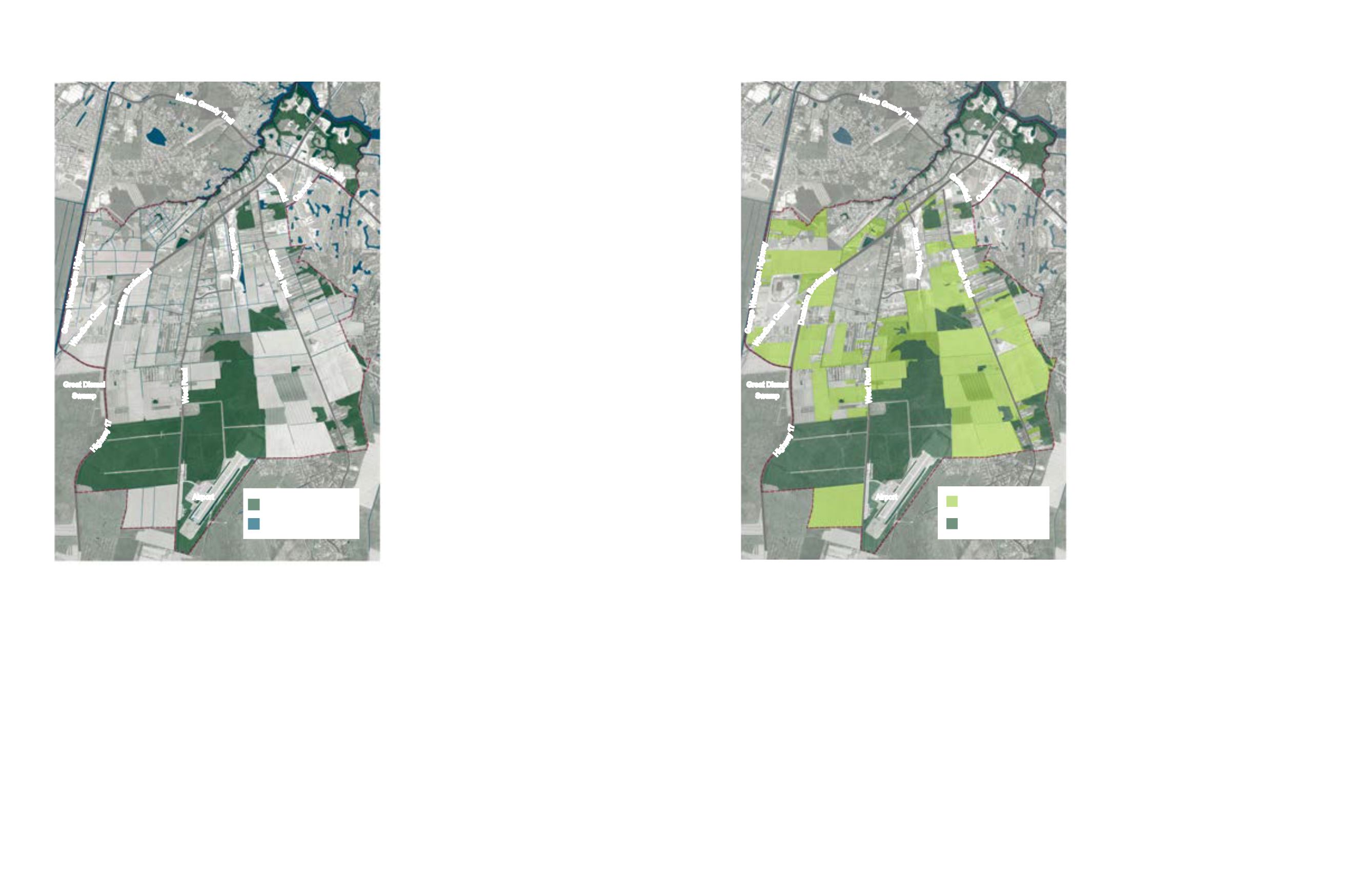
          Existing Hydrology and National
        
        
          Wetlands Inventory Map
        
        
          The existing hydrological patterns are
        
        
          important features and potential assets to
        
        
          leverage given the Study Area’s location
        
        
          next to the Great Dismal Swamp National
        
        
          Wildlife Refuge Area and the Elizabeth
        
        
          River.
        
        
          The National Wetlands Inventory was used
        
        
          to identify potential wetlands in the Study
        
        
          Area. According to the inventory, most of
        
        
          the site’s forested areas are likely to contain
        
        
          wetlands and protect sensitive habitat and
        
        
          biodiversity.
        
        
          There is a large portion of potential wetlands
        
        
          in the south portion of the site, providing a
        
        
          connection from the Great Dismal Swamp
        
        
          National Wildlife Refuge Area through the
        
        
          Study Area.
        
        
          Canals line the edges of properties and
        
        
          many roadways to assist with stormwater
        
        
          and flood management. Some of these
        
        
          canals are small in scale at 1-2 feet wide,
        
        
          while others, like the historic Herring Ditch,
        
        
          are 20-30 feet wide.
        
        
          By mapping and highlighting the hydrologic
        
        
          features, new development will work in
        
        
          concert with the hydrology of the Study
        
        
          Area. Although this inventory is not infallible,
        
        
          and some of the forested areas may turn
        
        
          out not to be wetlands, it is a starting point
        
        
          to identify land that is likely unsuitable
        
        
          for development and should be protected
        
        
          in its natural condition. This will provide
        
        
          environmental as well as recreational
        
        
          benefits and will promote a plan that is in
        
        
          character with the Study Area’s adjacency
        
        
          to the Great Dismal Swamp National Wildlife
        
        
          Refuge Area.
        
        
          Existing Agricultural Land
        
        
          Agriculture shapes much of the image,
        
        
          character and lifestyle of the Study Area. It
        
        
          is something that the Community wishes to
        
        
          preserve as much as practical. Protecting
        
        
          agricultural resources is part of a smart,
        
        
          holistic growth plan and should be taken
        
        
          seriously in the Study Area.
        
        
          Small scale and large scale agricultural
        
        
          activity is still prevalent in the Study Area
        
        
          in the form of large tracts of commercial
        
        
          operations and small agricultural
        
        
          homesteads. In all, approximately 4,000
        
        
          acres are currently being farmed.
        
        
          Many of the large farms are concentrated
        
        
          along Shillelagh Road, south of the Herring
        
        
          Ditch in the southeastern quadrant of the
        
        
          Study Area. There are also concentrations
        
        
          of agricultural activity in the western
        
        
          portion of the Study Area, along Dominion
        
        
          as it turns to Highway 17 and near the
        
        
          George Washington Highway. Agricultural
        
        
          land is also found along the south side of
        
        
          Drumcastle Lane and follows on to both
        
        
          sides of West Road moving south, and again
        
        
          between Number Ten Lane and Herring
        
        
          Ditch Road.
        
        
          Mapping the land used for agriculture will
        
        
          bring attention to it so that a master plan
        
        
          can be created that can preserve the most
        
        
          sensible portions of it - such as the large
        
        
          areas located in the southern portion of the
        
        
          Study Area.


            Figure 18: Existing hydrologic features including canals, ditches and


            forested land cataloged on the National Wetlands Inventory


            Figure 19: Existing agricultural lands


          Moses
        
        
          G
        
        
          r
        
        
          a
        
        
          n
        
        
          d
        
        
          y
        
        
          T
        
        
          r
        
        
          a
        
        
          i
        
        
          l
        
        
          Ceda
        
        
          r Ro
        
        
          a
        
        
          d
        
        
          Domi
        
        
          n
        
        
          i
        
        
          o
        
        
          n
        
        
          B
        
        
          o
        
        
          u
        
        
          l
        
        
          e
        
        
          v
        
        
          a
        
        
          r
        
        
          d
        
        
          G
        
        
          r
        
        
          a
        
        
          s
        
        
          s
        
        
          i
        
        
          e
        
        
          l
        
        
          d
        
        
          Shillelagh Roa
        
        
          d
        
        
          George Washington Highwa
        
        
          y
        
        
          Hig
        
        
          h
        
        
          w
        
        
          a
        
        
          y
        
        
          1
        
        
          7
        
        
          W
        
        
          e
        
        
          s
        
        
          t
        
        
          R
        
        
          o
        
        
          a
        
        
          d
        
        
          Scenic Pa
        
        
          r
        
        
          k
        
        
          w
        
        
          a
        
        
          y
        
        
          C
        
        
          a
        
        
          h
        
        
          o
        
        
          o
        
        
          n
        
        
          Whedbee
        
        
          C
        
        
          o
        
        
          r
        
        
          r
        
        
          e
        
        
          l
        
        
          Airport
        
        
          Great Dismal
        
        
          Swamp
        
        
          Hydrology/Canals + Ditches
        
        
          Wetlands (per NWI Inventory)
        
        
          1870 acres
        
        
          Forested Land
        
        
          1870 acres
        
        
          Existing Agricultural Land
        
        
          3800 acres