DOMINION BOULEVARD CORRIDOR STUDY | Chesapeake, Virginia
20 | Market Study
Market Study | 21
Market Study Summary
Background and Objectives
The City of Chesapeake is a thriving
economic hub supported by excellent
infrastructure, schools and location and
driven by substantial growth of the logistics,
manufacturing, sustainable energy and
startup sectors. The Dominion Boulevard
Corridor Study planning effort will build upon
the foundation established in the Moving
Forward Chesapeake 2035 Comprehensive
Plan to develop a strategy for development
of the corridor.
RCLCO researched and analyzed relevant
demographic and economic data for the
Study Area, city, and the region. Our
goal was to understand the City’s past
and present population and household
characteristics as well as trends or
projections that could be concluded for
incorporation into the development of the
Dominion Boulevard Corridor Study and
Economic Development Strategic Plan.
We considered both short- and long-term
projections and opportunities.
Our approach to this assignment included
an assessment of the area’s potential to
become a regional employment center and
a market analysis of the residential, retail
commercial, and office/industrial markets in
order to recommend market-driven impacts
to the land plan and create a land-use
allocation strategy and development phasing
schedule. This document summarizes the
Demographic Analysis and Market and
Economic Research and Analysis. The
market analysis was completed in Summer
of 2014.
The Market Study was prepared based
on the best information available at the
time. In recognition that market conditions
may change in the future, the Master Plan
should remain dynamic and flexible for new
opportunities that may arise.
provides long-term favorable growth
ject area is in a strong location to
t growth.
imately 10,000 acres in the City of
Study Area Relative to the MSA and the City of Chesapeake
outhwest of th St el Bridge, and is
ard corridor. It is east of The Great
a well-regarded place to live and do
o of the region’s employment cores
nd has some of the region’s newest
ould see additional development as the
th River is constructed, eliminating the
will have a toll. Since many bridges in
e projected to be at a higher rate,
the
pact on the desirability of the area
vard is being wid ned to a four lane
way into North Carolina. There is
int it will be turned into an interstate
ms are promising for the future
Figure 6: Virginia Beach-Norfok-Newport News
MSA, City of Chesapeake, and Dominion
Boulevard Study Area
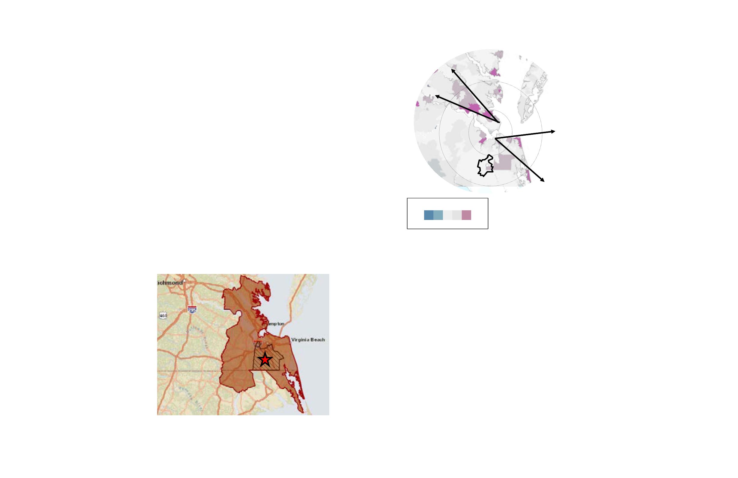
The favored quarter is a defining
characteristic of regional growth in most
regions, and the Hampton Roads region
is no exception. The favored quarter is
typically where the best paying jobs,
particularly office jobs, concentrate; on
average about 30-40% of these jobs locate
in what RCLCO has deemed to be Metro
Cores, the areas of greatest job density.
The Hampton Roads region has two distinct
favored quarters: one to the southeast
towards the water in Virginia Beach and the
other to the north into the Peninsula (see
Figure 7). Given the size of the region, it
would typically only have one direction of
growth, however, due to the unique nature
of the region with the ocean, rivers, and
multiple bridges, the region has grown in
multiple directions, following the water. The
Dominion Study Area is outside of these
traditional Favored Quarters, however, as
land becomes more scarce, and given the
size of the area, the Study Area could begin
to help shift the favored quarter towards it
over time.
The majority of employment is concentrated
along major transportation routes. Much of
this density is concentrated in downtown
Norfolk and directly to the east, towards
Virginia Beach, within one of the region’s
favored quarters. These dense employment
areas are the region’s Metro Cores.
Today, the Hampton Roads region has
nine established employment cores, with
one additional emerging. For the purpose
of this analysis, we only concentrated on
the seven employment cores in the South
side. The distinct location of each of these
cores is primarily driven by access to major
transportation routes, the unique topography
of the region that divides areas seemingly
next to each other on a map, and other
catalysts such as the location of regional
employment locations like Oceana Naval Air
Station. Approximately 30% of the current
Key Findings – Economy and Demographics
employment base in the Hampton Roads
region is contained within these seven
cores. The Dominion Study Area is close
to the Cavalier and Greenbrier Cores. See
Figure 8.
The Virginia Beach-Norfolk-Newport News
MSA (VA Beach MSA) is poised to see
moderate growth in the next 20 years (see
Figure 8). Many of the industries upon which
the region has grown (military, contractors,
transportation, and government) are
projected to have moderate to weak future
growth.
However, there are strong sectors of future
economic growth that should positively
impact the region including Professional
and Business Services, Health Services,
and Construction. In addition, the City
of Chesapeake is working hard to bring
employment base to the Hampton Roads
region within the cores most beneficial to the
City, which includes the potential Dominion
Boulevard Corridor.
Figure 7: Favored
Quarter of Growth in
Hampton Roads region
and Per Capita Income
Source: RCLCO and
ESRI
region has grown in multiple directions, following the water.
Per Capita Income
Hampton Roads Region
Industrial & Office Buildings
Hampton Roads Region
Peninsula
Favored
Quarter
10
20
South
Side
Favored
Quarter
Key: Per Capita Income (PCI)
Low Avg
High
MAP KEY
Industrial Buildings
Office Buildings
S C St
Dominion Boulevard | City of Chesapeake | April 11, 2014 | E4-11982.40
15
Source: Esri
ource: o ar


