DOMINION BOULEVARD CORRIDOR STUDY | Chesapeake, Virginia
26 | Market Study
Market Study | 27
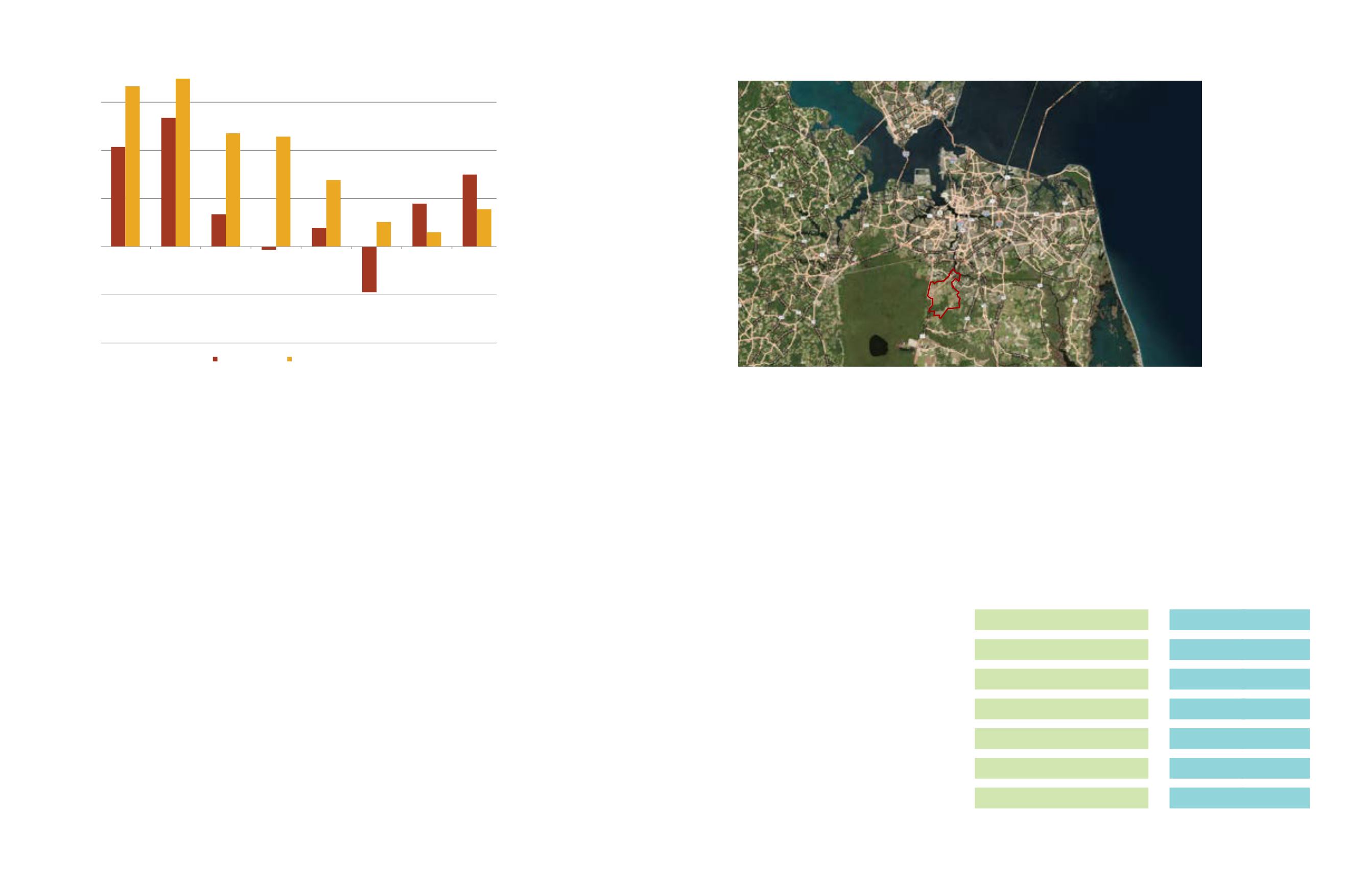
Figure 12: Office
Absorptions and
Completions, Virginia
Beach-Norfolk-Newport
News MSA; 2006-2013
Source: CoStar
Dominion Boulevard Site Analysis
The Study Area is approximately 10,000
acres in the City of Chesapeake. It is located
southwest of the Steel Bridge, and is along
the Dominion Boulevard corridor. It is east of
The Great Dismal Swamp Wildlife National
Refuge Area. See Figure 13.
The City of Chesapeake is a well-regarded
place to live and do business. It is home
to two of the region’s employment cores
(Greenbrier and Cavalier), and has some
of the region’s newest and nicest housing
stock.
The Dominion Study Area should see
additional development as the Veterans
Bridge over the Elizabeth River is
constructed, eliminating the Steel Bridge.
The new bridge will have a toll. Since many
bridges in the region are tolled, and some
projected to be at a higher rate, the toll
should have limited impact on the desirability
of the area for new construction.
In addition, Dominion Boulevard is being
widened to a four lane divided highway
all the way into North Carolina. There is
speculation that at some point it will be
turned into an interstate highway. All of these
items are promising for the future development
of the area.
The Study Area itself has some development
at the northern end, primarily residential
and retail. Throughout the Study Area there
are large lot single-family homes. Tidewater
Community College has a new facility as
well as the new Grassfield High School.
To the southern end of the Study Area is
the Chesapeake Regional Airport. The key
strengths, challenges, and opportunities for the
Study Area are provided in Table 2.
Demand Analysis
RCLCO completed a statistical demand
analysis for each of the land uses. The
residential demand models are based upon
household growth in the region, the percent
of new households likely to be either renters
or owners, and the interest in those renters
or owners in locating within the City of
Chesapeake, and then within the study area.
The retail demand model is based upon the
two scenarios of household growth within
the study area. Each household in the overall
region supports approximately 85 square feet
of retail. We multiplied the new households
Source:Esri,DigitalGlobe,GeoEye, i-cubed,EarthstarGeographics,CNES/AirbusDS,USDA,USGS,AEX,Getmapping,Aerogrid, IGN, IGP, swisstopo,and theGISUser
Community,Esri,HERE,DeLorme,MapmyIndia,©OpenStreetMap contributors
Figure 13: Subject
Site Location
by the estimated square feet of retail
they support to understand the long-term
opportunity for retail in the study area.
The office and industrial demands are based
upon projected employment growth in the
region, the conversion of those employees
into square feet of office/industrial, and the
capture of the square feet in the Study Area.
Utilizing the market analysis demand
summary data from Table 1, as well as the
subsequent residential and non-residential
yield assumptions from Table 3 on page 29,
Design Workshop created a Master Land
Use Plan for the study area that incorporates
urban form and design principles, tailored to
the specific land use preferences expressed
during the public input workshops and
other stakeholder sessions. Because of
the strong emphasis on strategic economic
development within the study, great care
was taken to factor in the market study’s
full build-out yield assumptions for non-
residential land uses. With respect to
residential allocations in the Master Land
Use Plan, the yields are compatible with
the market study’s yield assumptions at
full build-out, although the Plan advocates
a phased approach, with residential
development occurring first in the focal
2,278
448
2,726
240,319
233,693
114,859
588,871
2014-2024
For-Sale Residential
For-Rent Residential
Total Residential
Retail SF
Office SF
Industrial SF
Total SF Commercial
Summary of Demand
1,871
579
2,450
214,722
482,966
28,273
725,961
2025-2035
Table 1: Regional Employment Scenario Demand Summary
VIRGINIA BEACH-NORFOLK-NEWPORT NEWS, VA-NC MSA
2006-2013
500,000
1,000,000
1,500,000
2,000,000
2006-2013 Avg. Absorption:
450,000
2006-2013 Avg. Completion:
900,000
SOURCE: CoStar
(1,000,000)
(500,000)
-
2006
2007
2008
2009
2010
2011
2012
2013
Net Absorption Completions
Exhibit V-17
E4-11982.40
Printed: 3/27/2014
development areas. While the residential
units and non-residential square footages
projected to be generated from proposed
new land uses do not correlate exactly
with the market study yield assumptions,
the Master Land Use Plan creates a
balanced and supportable arrangement of
residential densities and non-residential
land uses that will accommodate a regional
employment center, urban core areas, and
supporting open spaces, public uses, and
infrastructure.


