 
          DOMINION BOULEVARD CORRIDOR STUDY  |  Chesapeake, Virginia
        
        
          38  |  Existing Conditions
        
        
          Existing Conditions  |  39
        
        
          Landscape Features
        
        
          Existing Rural Development
        
        
          Rural Development Lots
        
        
          Preserving a rural way of life was a
        
        
          value expressed by the Community. Like
        
        
          agriculture, it provides much of the existing
        
        
          character and image of the Study Area. It is
        
        
          why people traditionally have chosen to live
        
        
          in this part of Chesapeake.
        
        
          Rural development occupies approximately
        
        
          20% of the Study Area. Much of the rural
        
        
          development has occurred in 3 acre “piano
        
        
          key” lots along the north/south roads that
        
        
          connect to Dominion such as Shillelagh
        
        
          Road, West Road and along George
        
        
          Washington Highway. Number Ten Lane
        
        
          and Herring Ditch Road, parallel roads
        
        
          which intersect West Road, also have a
        
        
          concentration of the 3 acre residential lots.
        
        
          Mapping the rural lots provides guidance for
        
        
          how to phase in new development, where to
        
        
          locate new roads and neighborhoods and
        
        
          where it may be appropriate to promote long
        
        
          term preservation.
        
        
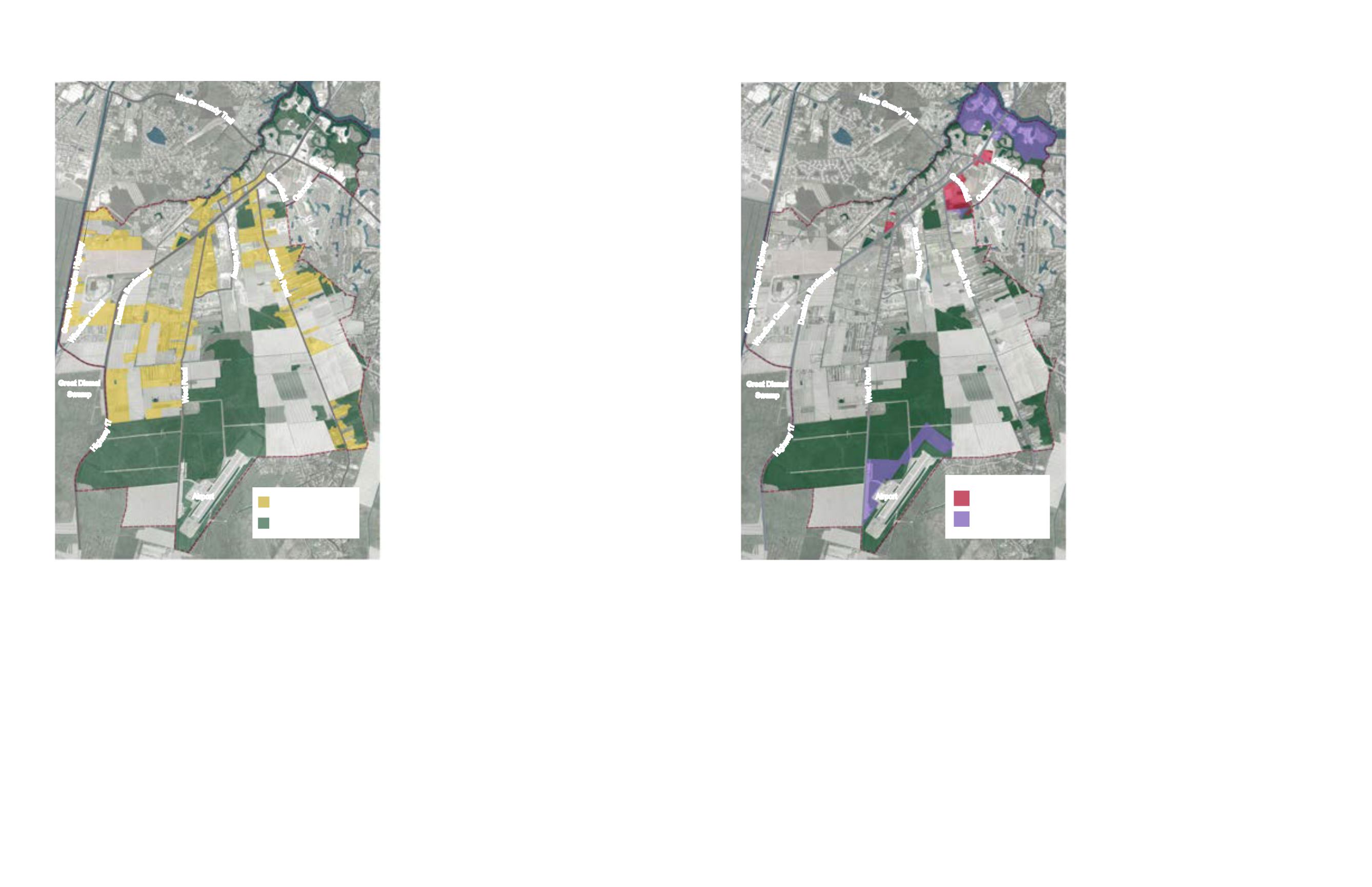
          Industrial and Commercial Nodes
        
        
          Supporting jobs creating uses is an
        
        
          important part of creating a successful plan
        
        
          for the future of Chesapeake. The Study
        
        
          Area has seen recent new Industrial and
        
        
          Commercial development along the eastern
        
        
          portion of Dominion Boulevard. These
        
        
          initial areas of commercial and industrial
        
        
          development require nourishment in the
        
        
          form of access, roof tops and like minded
        
        
          uses if they are to realize their true potential.
        
        
          Along the Elizabeth River, in the northern
        
        
          portion of the Study Area, are pockets
        
        
          of land zoned for industrial use that take
        
        
          advantage of river access and the location
        
        
          along Dominion Boulevard. The largest
        
        
          concentration of commercial use is along
        
        
          the south side Dominion Boulevard between
        
        
          Grassfield Parkway and Shillelagh Road
        
        
          - serving new residential neighborhoods
        
        
          in the area. At the southern end of the
        
        
          Study Area is the Chesapeake Regional
        
        
          Airport, which creates an opportunity for
        
        
          light industrial and commercial uses. There
        
        
          are pockets of commercial properties along
        
        
          Cedar Road and at the intersection of Cedar
        
        
          and Dominion.
        
        
          By mapping these areas, the plan can best
        
        
          support the City’s efforts to create jobs in
        
        
          the region and to attach consistent uses
        
        
          along side of them so that their influence
        
        
          grows.


            Figure 21: Existing commercial and industrial development throughout the


            study area


            Figure 20: Existing rural residential lots in the study area


          Moses
        
        
          G
        
        
          r
        
        
          a
        
        
          n
        
        
          d
        
        
          y
        
        
          T
        
        
          r
        
        
          a
        
        
          i
        
        
          l
        
        
          Ceda
        
        
          r Ro
        
        
          a
        
        
          d
        
        
          Domi
        
        
          n
        
        
          i
        
        
          o
        
        
          n
        
        
          B
        
        
          o
        
        
          u
        
        
          l
        
        
          e
        
        
          v
        
        
          a
        
        
          r
        
        
          d
        
        
          G
        
        
          r
        
        
          a
        
        
          s
        
        
          s
        
        
          i
        
        
          e
        
        
          l
        
        
          d
        
        
          Shillelagh Roa
        
        
          d
        
        
          George Washington Highwa
        
        
          y
        
        
          Hig
        
        
          h
        
        
          w
        
        
          a
        
        
          y
        
        
          1
        
        
          7
        
        
          W
        
        
          e
        
        
          s
        
        
          t
        
        
          R
        
        
          o
        
        
          a
        
        
          d
        
        
          Scenic Pa
        
        
          r
        
        
          k
        
        
          w
        
        
          a
        
        
          y
        
        
          C
        
        
          a
        
        
          h
        
        
          o
        
        
          o
        
        
          n
        
        
          Whedbee
        
        
          C
        
        
          o
        
        
          r
        
        
          r
        
        
          e
        
        
          l
        
        
          Airport
        
        
          Great Dismal
        
        
          Swamp
        
        
          Forested Land
        
        
          1870 acres
        
        
          Existing Rural Residential
        
        
          Development
        
        
          1775 acres
        
        
          Light Industry
        
        
          660 acres
        
        
          Business / Commercial
        
        
          115 acres