DOMINION BOULEVARD CORRIDOR STUDY | Chesapeake, Virginia
54 | Planning Frameworks
Planning Frameworks | 55
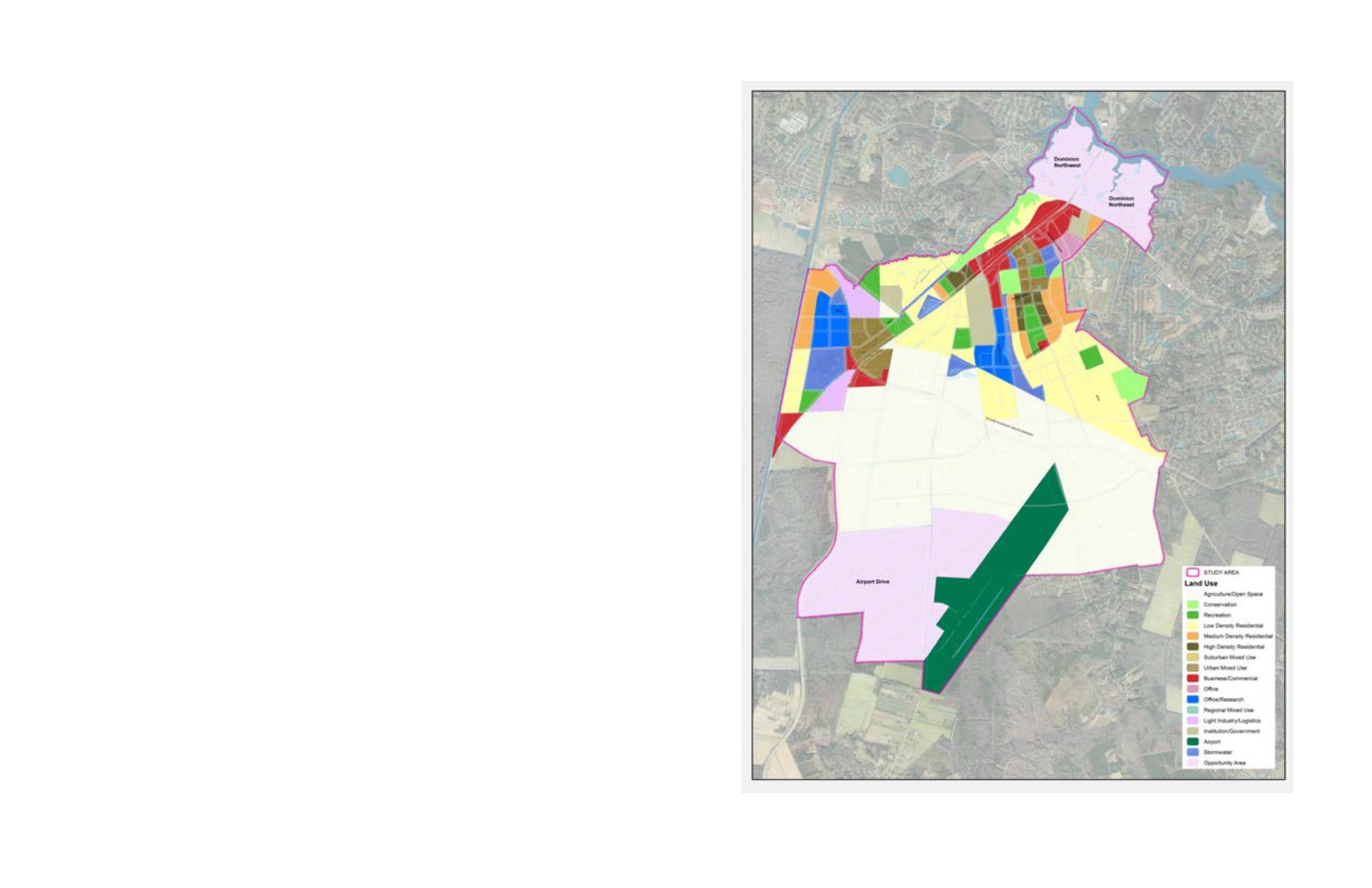
Master Land Use Plan
The settlement pattern appropriate for
the Study Area leans toward urban forms
with an organized network of connected,
gridded, multimodal streets, buildings that
front upon those streets, and centers and
edges that define neighborhoods and
districts. The relationship between buildings,
streets and gathering areas should be
carefully composed so that unique places
are created.
At a different scale, dense pockets
of development should be defined by
preserved open spaces, creating interplay
between settlement and preservation.
At its highest levels, this interplay should
enable open space networks, in the form
of greenways, water management systems
and linear parks, to penetrate into the urban
form to create linkages to nature. And in
most cases, homes and roads should front
onto open spaces so that their use and
enjoyment is shared by all.
Settlement patterns and densities should be
reflective of the theme and character of the
Area being planned for development. Within
the master plan there are Areas that lean
more towards urban and Areas that lean
more toward rural. Each of these should be
expressed with an appropriate development
pattern.
Urban areas should be designed so that
streets, parking, public spaces and dense
mixed use buildings create an opportunity
for diverse social and economic interactions.
Rural areas should be designed so that
they promote the preservation of agriculture
and provide settlement clusters on smaller
footprints that enable agriculture to continue
to function. Ideally there will be very little
suburban development, with homes spread
apart in a low density patterns, so that land
can be put to better use with jobs creating
uses or preserved in agriculture or open
space.
Implementation Recommendation
• Complete, or have plans to complete,
the development of an Area prior to
proceeding with subsequent Areas that
have similar land uses and only when
infrastructure extensions are available.
• Promote a dynamic mix of uses,
appropriate to the general theme of Areas
3 and 6, that lead toward higher levels of
livability and integration.
• Allow Mixed Use to respond to market
opportunities. The current plan considers
20% Retail, 35% Office and 45% Office
Research uses in the Mixed Use portions
of the plan.
• Promote appropriate housing densities to
create compact walkable neighborhoods
in Areas 3,4,5, 6 and 7. The current plan
uses maximum densities at: Urban Mixed
Use at 30 du/acre, HDR at 16 du/acre,
MDR at 10 du/ac and LDR at 4 du/ac.
• Provide adequate community services
based on need for Areas 3 and 6 which,
in general, includes an elementary school
and middle school for Area 3 and an
elementary school in Area 6. The City
should proactively identify sites for these
facilities through the development review
and capital planning processes. These
facilities should be integrated into the
neighborhood designs and located within
walking distance of 50% of the dwellings.
• Create an organized grid of “complete”
streets, transit routes and transit stops,
and greenways to enable multimodal
connectivity in Areas 3, 4, 5 and 6.
• Plan Areas so that centers, nodes and
edges are created and so that buildings
frame streets, greenways, canals and
open spaces.
• Preserve and protect sensitive
environmental features when planning
future developments.
Figure 30: The Master Land Use Plan outlines the study area’s
proposed development patterns


