 
          DOMINION BOULEVARD CORRIDOR STUDY  |  Chesapeake, Virginia
        
        
          98  |  Infrastructure Strategy
        
        
          Infrastructure Strategy  |  99
        
        
          Transportation Master Plan


            Speed and Road Configuration


          Dominion Boulevard is an Urban Principal Arterial maintained by the City of Chesapeake.
        
        
          The speed limit along Dominion Boulevard is posted at 45 miles per hour (mph) south of
        
        
          Cedar Road through most of the study area. Dominion Boulevard currently has three (3) sig-
        
        
          nalized intersections and one (1) unsignalized intersection in the study area. They include:
        
        
          Dominion Boulevard and Cedar Road/Moses Grandy Trail
        
        
          Dominion Boulevard and Grassfield Parkway
        
        
          Dominion Boulevard and Scenic Parkway
        
        
          Dominion Boulevard and George Washington Highway (unsignalized)
        
        
          The intersections on the East and West sides of Dominion Boulevard within the study area
        
        
          are the following:
        
        
          Cedar Road and Cahoon Parkway
        
        
          Grassfield Parkway and Cahoon Parkway
        
        
          Shillelagh Road and Cahoon Parkway
        
        
          Drumcastle Lane and West Road
        
        
          Moses Grandy Trail and Cedar Road
        
        
          Cedar Road and Scenic Parkway
        
        
          The studied base condition was based upon the year 2050 forecasted lane configuration
        
        
          from the City’s Master Transportation Plan. The base condition roadway network consists of
        
        
          the configuration in the table below:


            Limits


            Corridor


            Number of Lanes


          South of Cedar Rd
        
        
          Dominion Blvd.
        
        
          8
        
        
          East of Dominion Blvd
        
        
          Cedar Rd
        
        
          6
        
        
          South of Moses Grandy Trail
        
        
          2
        
        
          West of Dominion Blvd
        
        
          Moses Grandy Trail
        
        
          4
        
        
          East of Dominion Blvd
        
        
          Grassfeld Parkway
        
        
          4
        
        
          South of Dominion Blvd.
        
        
          Shillelagh Rd.
        
        
          2
        
        
          South of Dominion Blvd.
        
        
          Scenic Parkway
        
        
          4
        
        
          South of Dominion Blvd.
        
        
          West Rd.
        
        
          2
        
        
          South of Cedar Rd.
        
        
          Cahoon Parkway
        
        
          4
        
        
          North of Dominion Blvd.
        
        
          George Washington Hwy.
        
        
          4


            Existing Traffic Volumes


          The Average Daily Traffic (ADT) volumes for the study area were provided by the City of
        
        
          Chesapeake and obtained from other publicly available sources.  No traffic counts were
        
        
          done in conjunction with this study. Background traffic data is shown in the following table.
        
        
          The traffic volumes were grown to the current year 2014 utilizing a 3 percent growth rate per
        
        
          year and grown 1 percent per year to the 2034 studied year, which was provided by the City
        
        
          of Chesapeake Traffic Engineering Department.
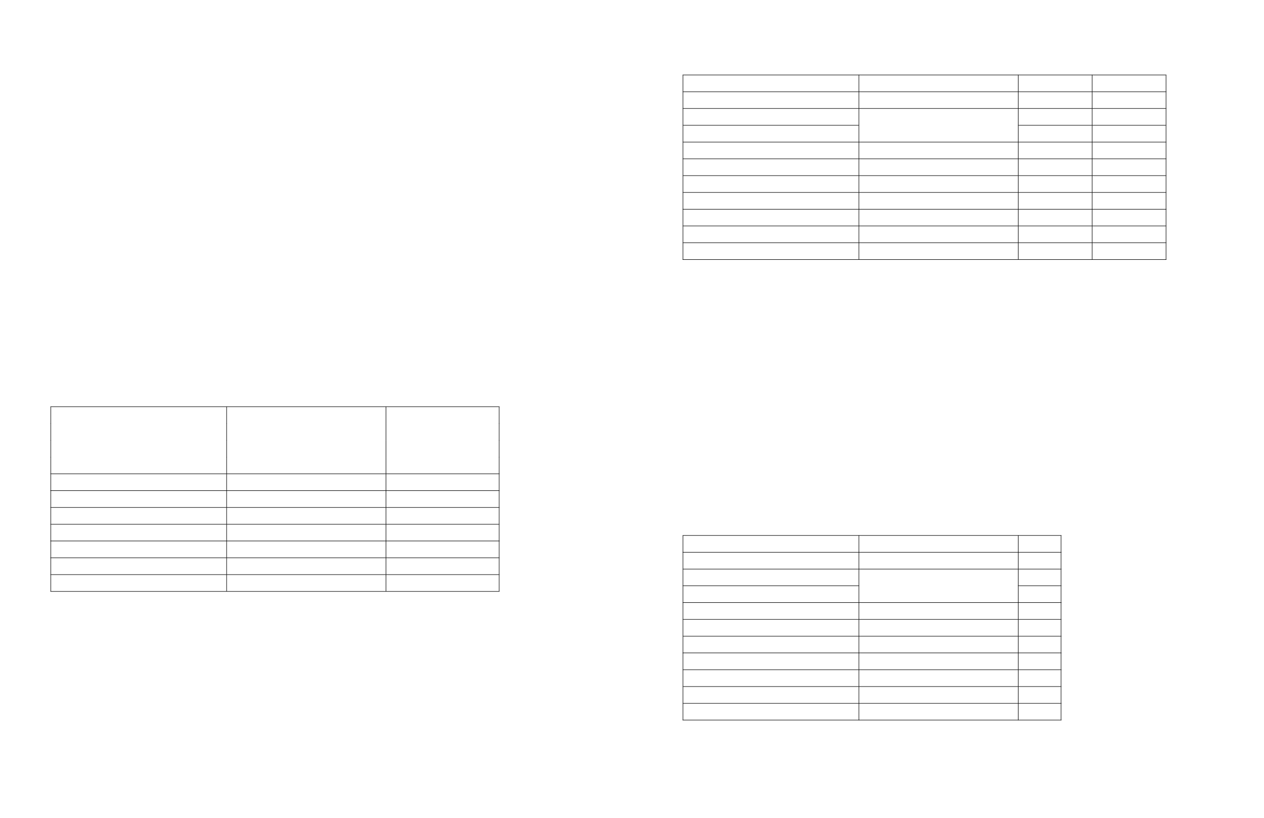


            Limits


            Corridor


            2014 ADT


            2034 ADT


          South of Cedar Rd
        
        
          Dominion Blvd.
        
        
          11,990
        
        
          14,630
        
        
          East of Dominion Blvd
        
        
          Cedar Rd
        
        
          26,160
        
        
          31,920
        
        
          South of Moses Grandy Trail
        
        
          6,980
        
        
          8,517
        
        
          West of Dominion Blvd
        
        
          Moses Grandy Trail
        
        
          13,080
        
        
          15,960
        
        
          East of Dominion Blvd
        
        
          Grassfeld Parkway
        
        
          7,440
        
        
          9,078
        
        
          South of Dominion Blvd.
        
        
          Shillelagh Rd.
        
        
          2,530
        
        
          3,087
        
        
          South of Dominion Blvd.
        
        
          Scenic Parkway
        
        
          5,220
        
        
          6,369
        
        
          South of Dominion Blvd.
        
        
          West Rd.
        
        
          3,220
        
        
          3,929
        
        
          South of Cedar Rd.
        
        
          Cahoon Parkway
        
        
          10,360
        
        
          12,641
        
        
          North of Dominion Blvd.
        
        
          George Washington Hwy.
        
        
          4,560
        
        
          5,564
        
        
          The ADT volumes are slightly higher on the northern end of the study area, since some
        
        
          development has already occurred around Cahoon Parkway, Grassfield Parkway, and
        
        
          Scenic Parkway. A residential development is located off of Cahoon Parkway along with
        
        
          Cedar Road Elementary School. Development along Grassfield Parkway consists of a Wal-
        
        
          Mart, Applebee’s, and a few other retail stores.  Grassfield High School is located along
        
        
          Scenic Parkway.


            Existing Level of Service


          According to the Highway Capacity Manual 2010, a two-lane highway operates at an
        
        
          acceptable capacity at 3,200 passenger cars per hour (pc/h) for two directions.  Multilane
        
        
          highways with flow rates over 1,400 passenger cars per hour per lane (pc/h/ln) result in
        
        
          speeds below the highways free flow speed.  Level of Service (LOS) is used to categorize
        
        
          the segments of the corridors. LOS ranges from A through F and is determined by the
        
        
          density along the roadway.  A roadway with a higher density will cause the free flow speed
        
        
          to decrease which will lower the LOS. The table below describes the existing level of service
        
        
          based on density for the corridors located in the study area.


            Limits


            Corridor


            LOS


          South of Cedar Rd
        
        
          Dominion Blvd.
        
        
          A
        
        
          East of Dominion Blvd
        
        
          Cedar Rd
        
        
          N/A
        
        
          South of Moses Grandy Trail
        
        
          A
        
        
          West of Dominion Blvd
        
        
          Moses Grandy Trail
        
        
          B
        
        
          East of Dominion Blvd
        
        
          Grassfeld Parkway
        
        
          A
        
        
          South of Dominion Blvd.
        
        
          Shillelagh Rd.
        
        
          A
        
        
          South of Dominion Blvd.
        
        
          Scenic Parkway
        
        
          A
        
        
          South of Dominion Blvd.
        
        
          West Rd.
        
        
          A
        
        
          South of Cedar Rd.
        
        
          Cahoon Parkway
        
        
          A
        
        
          North of Dominion Blvd.
        
        
          George Washington Hwy.
        
        
          A


            Table 4: Existing roadway network configurations


            Table 5: Average daily traffic for key intersections


            Table 6: Existing level of service at key intersections