DOMINION BOULEVARD CORRIDOR STUDY | Chesapeake, Virginia
108 | Infrastructure Strategy
Infrastructure Strategy | 109
• Single northbound left turn lane
• Dual southbound left turn lanes
• Scenic north of Dominion is dual left turn lanes and two through lanes with a shared
right turn lane
• Scenic south of dominion is dual left turn lanes, two through lanes and one right turn
lane (operates as a free movement)
Dominion Blvd. & Pleasant Grove Parkway
• New signalized intersection
• Four through lanes in each direction on Dominion Blvd.
• Single northbound and southbound left turn lanes
• Single northbound right turn lane
• Single southbound right turn lane (operates as a free movement)
• Two eastbound and westbound through lanes
• Single eastbound and westbound left turn lanes
• Single eastbound right turn lane
• Single westbound right turn lane (operates as a free movement)
Dominion Blvd. & George Washington Highway
• Proposed signalized location
• Two through lanes in each direction on Dominion Blvd.
• Single northbound left turn lane
• Single southbound right turn lane
• Dual eastbound left turn lanes
• Single eastbound right turn lane
Cedar Road & Cahoon Parkway
• Remove the split phasing from the signal and provide standard NEMA phasing
(8-phase)
• Three through lanes in each direction on Cedar Road
• Dual left turn lanes in each direction on Cedar Road
• Dual eastbound right turn lanes
• Dual northbound left turn lanes
• Single northbound right turn lane (operates as a free movement)
• Single north and southbound through lanes
• Single southbound left and right turn lanes.
Moses Grandy Trail & Cedar Road
• Two through lanes in each direction on Moses Grandy Trail
• Single eastbound left turn lane
• Dual westbound left turn lanes
The studied intersections should be evaluated with each stage of construction to ensure the
proper amount of turn lane storage and level of service is maintained including retiming of
the existing signal corridor. The intersection of Dominion Boulevard and George Washington
Highway should be monitored closely for possible signalization.
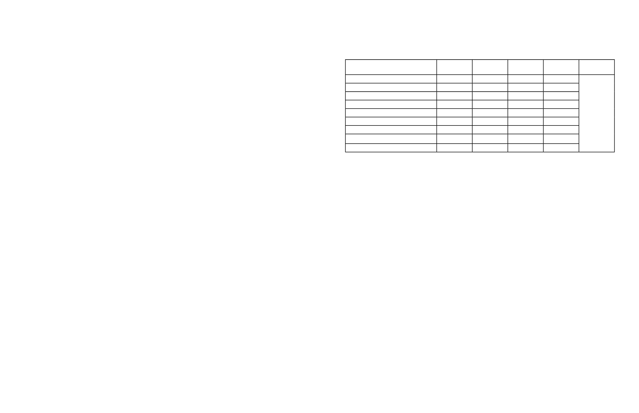
The following table details the roadway improvements needed and estimated construction
costs associated with the improvements.
Main Throughfare Roadway
Existing
Cross-Section
Proposed
Cross-Section
Estimated
Cost
Contingency
20%
Total Cost
Dominion Blvd
4-Lane
8-Lane
$3,960,000 $792,000
$43,777,530
Miscellaneous Turn Lanes
$529,000 $105,800
Signalization Improvements
$1,100,000 $220,000
Shillelagh Rd
2-Lane
4-Lane
$7,590,000 $1,518,000
Cedar Rd (East of Dominion)
4-Lane
6-Lane
$1,500,000 $300,000
Cedar Rd (South of Moses Grandy Tr)
2-Lane
4-Lane
$2,390,850 $478,170
Scenic Pkwy
2 & 4-Lane
4-Lane
$4,231,425 $846,285
George Washington Hwy
2-Lane
4-Lane
$7,590,000 $1,518,000
Pleasant Grove Pkwy
-
4-Lane
$7,590,000 $1,518,000
The above estimated costs are only construction costs based on widening the existing facilities
to include a concrete median, curbed roadways, and bike lanes. Right-of-way, engineering
and inflation costs are not included in the estimate. The internal connector roads associated
with each Area were not evaluated during the analysis. The existing cross-sections listed are
based on the 2050 Chesapeake Transportation Plan and the recommendations of this study.
Proposed frontage roads shall be considered with caution. If the roads are in too close
proximity to a high traffic volume intersection then queues have the potential to back up
into the upstream or downstream intersection. There should be a minimum of 650 feet from
any intersection to a frontage road. If a frontage road is less than 650 feet from a near-by
intersection then access shall be restricted to right-in/right-out only. The current study’s plan
follows a minimum of 650 feet spacing from a high traffic volume intersection.
The proposed locations of future signal locations shall be determined by the land developer
by completing a traffic impact study for any development generating greater than 100 primary
trips in the peak hour or at the request of the City. Spacing of signals shall be no less than
½ mile unless authorized by the City. The potential locations of traffic signals are Dominion
Boulevard and George Washington Highway, Scenic Parkway and Shillelagh Road, Shillelagh
Road and Pleasant Grove Parkway, and West Road and Pleasant Grove Parkway.
The future Pleasant Grove Parkway will be a limited-access arterial with a 45 mph design
speed and on-street parking is not allowed. Access points along the parkway should be
limited and will in most cases require a traffic signal at these intersections.
There are many resources available for fnancial support to help build the infrastructure that
is needed. Outside of raising city taxes the city could allow TIF’s (Tax Increment Financing).
This is a method to allow developers to use their future gains to pay for infrastructure
improvements. There is also the Virginia Economic Development Incentive Grant Program,
Revenue Sharing Funds available from VDOT, and Regional Surface Transportation Program
(RSTP) Funds. All of these funding sources could help to provide fnancial support to the
infrastructure upgrades needed to support the anticipated development along the Dominion
Boulevard corridor.
Table 14: Estimated cost summary table


