DOMINION BOULEVARD CORRIDOR STUDY | Chesapeake, Virginia
106 | Infrastructure Strategy
The volumes generated for the proposed land use scenarios are expected to generate ac-
ceptable levels of service at all of the studied intersections. Dominion Boulevard and George
Washington Highway is signalized in the build scenario.
Recommendations
Based on the ADT projections and the design hourly volumes for 2035, recommendations
were developed for the roadway functional classification and typical section.
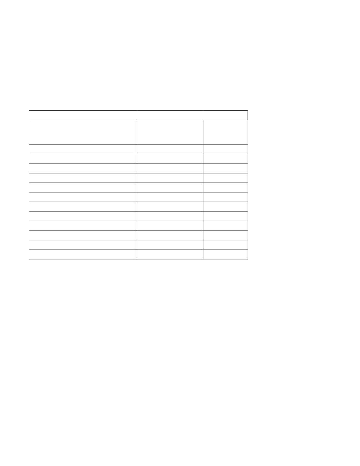
Transportation Network
Street
Functional
Classifcation
Proposed
Number of
Lanes
Dominion Blvd
Principal Arterial
8
Cedar Rd (East of Dominion)
Arterial
6
Cedar Rd (South of Moses Grandy)
Collector
4
Moses Grandy Trail
Local Road
4
Grassfeld Parkway
Arterial
4
Shillelagh Rd
Local Road
2
Scenic Parkway
Arterial
4
West Rd
Local Road
2
Pleasant Grove Parkway
Arterial
4
Cahoon Parkway
Collector
4
George Washington Highway
Arterial
4
Interior Area Roads
Local Road
2
The road sections listed all correspond to the 2050 Transportation Plan except Cedar Road
south of Moses Grandy Trail. Based on the expected growth it is recommended that Cedar Road
south of Moses Grandy Trail be four (4) lanes instead of two (2). This will allow for better traffic
flow through the study area. The graphic illustrates the proposed number of lanes.
The following are anticipated intersection geometries for each studied intersection (Dominion
Boulevard is assumed the north/south roadway within these descriptions):
Dominion Blvd. & Cedar/Moses Grandy Trail
• No changes recommended.
Dominion Blvd. & Grassfield Parkway
• Four through lanes in each direction on Dominion Blvd.
• Northbound right turn lane
• Dual southbound left turn lanes
• Dual left turn lanes and a single right turn lane on Grassfield
Dominion Blvd. & Scenic Parkway
• Four through lanes in each direction on Dominion Blvd.
• Northbound right turn lane (operates as a free movement)
• Southbound right turn lane
Table 13: Roadway functional classifications


