DOMINION BOULEVARD CORRIDOR STUDY | Chesapeake, Virginia
98 | Infrastructure Strategy
Transportation Master Plan
Speed and Road Configuration
Dominion Boulevard is an Urban Principal Arterial maintained by the City of Chesapeake.
The speed limit along Dominion Boulevard is posted at 45 miles per hour (mph) south of
Cedar Road through most of the study area. Dominion Boulevard currently has three (3) sig-
nalized intersections and one (1) unsignalized intersection in the study area. They include:
Dominion Boulevard and Cedar Road/Moses Grandy Trail
Dominion Boulevard and Grassfield Parkway
Dominion Boulevard and Scenic Parkway
Dominion Boulevard and George Washington Highway (unsignalized)
The intersections on the East and West sides of Dominion Boulevard within the study area
are the following:
Cedar Road and Cahoon Parkway
Grassfield Parkway and Cahoon Parkway
Shillelagh Road and Cahoon Parkway
Drumcastle Lane and West Road
Moses Grandy Trail and Cedar Road
Cedar Road and Scenic Parkway
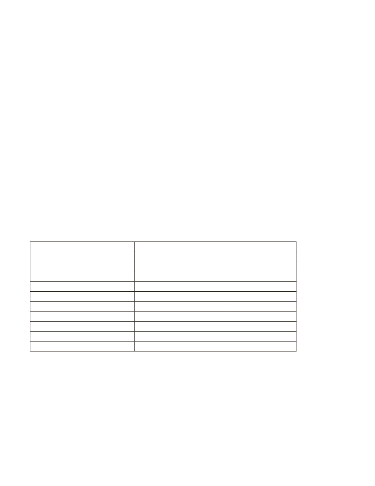
The studied base condition was based upon the year 2050 forecasted lane configuration
from the City’s Master Transportation Plan. The base condition roadway network consists of
the configuration in the table below:
Limits
Corridor
Number of Lanes
South of Cedar Rd
Dominion Blvd.
8
East of Dominion Blvd
Cedar Rd
6
South of Moses Grandy Trail
2
West of Dominion Blvd
Moses Grandy Trail
4
East of Dominion Blvd
Grassfeld Parkway
4
South of Dominion Blvd.
Shillelagh Rd.
2
South of Dominion Blvd.
Scenic Parkway
4
South of Dominion Blvd.
West Rd.
2
South of Cedar Rd.
Cahoon Parkway
4
North of Dominion Blvd.
George Washington Hwy.
4
Existing Traffic Volumes
The Average Daily Traffic (ADT) volumes for the study area were provided by the City of
Chesapeake and obtained from other publicly available sources. No traffic counts were
done in conjunction with this study. Background traffic data is shown in the following table.
The traffic volumes were grown to the current year 2014 utilizing a 3 percent growth rate per
year and grown 1 percent per year to the 2034 studied year, which was provided by the City
of Chesapeake Traffic Engineering Department.
Table 4: Existing roadway network configurations


