DOMINION BOULEVARD CORRIDOR STUDY | Chesapeake, Virginia
36 | Existing Conditions
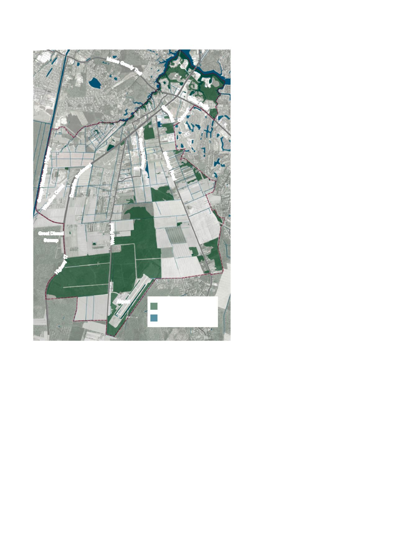
Existing Hydrology and National
Wetlands Inventory Map
The existing hydrological patterns are
important features and potential assets to
leverage given the Study Area’s location
next to the Great Dismal Swamp National
Wildlife Refuge Area and the Elizabeth
River.
The National Wetlands Inventory was used
to identify potential wetlands in the Study
Area. According to the inventory, most of
the site’s forested areas are likely to contain
wetlands and protect sensitive habitat and
biodiversity.
There is a large portion of potential wetlands
in the south portion of the site, providing a
connection from the Great Dismal Swamp
National Wildlife Refuge Area through the
Study Area.
Canals line the edges of properties and
many roadways to assist with stormwater
and flood management. Some of these
canals are small in scale at 1-2 feet wide,
while others, like the historic Herring Ditch,
are 20-30 feet wide.
By mapping and highlighting the hydrologic
features, new development will work in
concert with the hydrology of the Study
Area. Although this inventory is not infallible,
and some of the forested areas may turn
out not to be wetlands, it is a starting point
to identify land that is likely unsuitable
for development and should be protected
in its natural condition. This will provide
environmental as well as recreational
benefits and will promote a plan that is in
character with the Study Area’s adjacency
to the Great Dismal Swamp National Wildlife
Refuge Area.
Figure 18: Existing hydrologic features including canals, ditches and
forested land cataloged on the National Wetlands Inventory
Moses
G
r
a
n
d
y
T
r
a
i
l
Ceda
r Ro
a
d
Domi
n
i
o
n
B
o
u
l
e
v
a
r
d
G
r
a
s
s
i
e
l
d
Shillelagh Roa
d
George Washington Highwa
y
Hig
h
w
a
y
1
7
W
e
s
t
R
o
a
d
Scenic Pa
r
k
w
a
y
C
a
h
o
o
n
Whedbee
C
o
r
r
e
l
Airport
Great Dismal
Swamp
Hydrology/Canals + Ditches
Wetlands (per NWI Inventory)
1870 acres


